Chatter News Photo Galleries and Information ________________________________________________
| Chatter News | Road to Vertebrae Glacier | Glacier Skiing | Bombardier Snowcat | Favorites |
| Lodge Life | Vertebrae Lodge | Solitude Lodge | Happy Campers | Pink Purse | Winter Staff |
Ski Photography by: | John Dougall | Mark Gallup | Dan Hudson | Rob Plato | Site Map | Index |
| Chatter Creek Cat Skiing | Clamshell | Cut Blocks | East Ridge | Lodge Ridge | Great Links |
| Cat Skiing Terrain | Cat Skiing Articles | Flight to Chatter Creek | Travel to Golden | Email |

Tuesday, April 26, 2005

Chatter Creek Snowcat Skiing Office in Golden BC

Chatter Creek Office Location in Golden BC
The Chatter Creek Snowcat Skiing Office location in East (Upper) Golden. Cat Skiers joining a Chatter Creek tour meet at the Alpine Helicopters hanger at Golden Airport. Click the image for a better view.

Golden BC Aerial Photo

Golden BC Aerial Photo
Aerial View of Golden BC looking west. The TransCanada Highway from Lake Louise enters East Golden at the bottom of the photo. It then drops down a hill to a "strip" of gas stations, motels and eateries and continues north (right in the photo) to the Rogers Pass and Revelstoke. Part way along the "strip", Hwy 95 to Invermere and Radium branches off south to pass through downtown Golden at the left side of the photo. The routes to the Golden Airport and to the Kicking Horse Resort Ski Area start on Hwy 95. Click the image for a better view.

Click here to locate the Chatter Creek Snowcat Skiing Office.

Wednesday, April 20, 2005


xx


The lower slopes of Stovepipe Mountain, taken from Lodge Ridge. Megahooped is the entire area below the central bench across which runds the Road to Vertebrae glacier. Wonderland and Bouncing Chuckles are two separate sets of lines within Megahooped. Jo-Pal starts at the top of the Windlip and passes through a draw in the northern ridge before turning and dropping to the road on the bench, quite close th the Upper Lake. A road branches to the south and crosses upper East Ridge to Mullet Bowl, Steph's Thumb and makes contact with lower Super Spruce. Megahooped Trees lies at the bottom of Megahooped.

Saturday, April 16, 2005

Home Run on Lodge Ridge at Chatter Creek

The Home Run is a cut block (logged area) on the south end of Lodge Ridge, immediately above the site of Vertebrae and Solitude Lodges. Chatter Creek guests can ski and ride the home Run, right to the lodge door. The Road to Vertebrae glacier starts by traversing the Home Run.

1. Aerial view looking south from above Vertebrae lodge.
2. Aerial view of the Home Run cut block and the Lodge site with Lodge Ridge and Megahooped behind.
3. Summer view of the base of the Home Run.
4. The first snow on the Home Run heralds the closing days of the construction season.
5. Sunset over the Home Run
6. View of Vertebrae and Solitude Lodges from the Home Run
7. The top of the Home Run cut block.
8. Tailgunner, Matt Cochand on the Home Run.
9. Snowcats parked at the lodge with the base of the Home Run in the background.
10. South end of Lower Lodge Ridge with names.
Home Run on Lodge Ridge

Friday, April 15, 2005

Mommy's Run and Crystal Lite at Chatter Creek

Powder Skiing at Chatter Creek
The following link to photos taken of or on Mommy's Run and Crystal Lite, two popular cat skiing runs on the east side of Lodge Ridge at Chatter Creek.

1. Crystal Lite and Mommy's Run from Spruce Creek Gully
2. Crystal Lite at tree line on Lodge Ridge
3. On Mommy's Run looking down on Megahooped Trees
4. Riding on Mommy's Run
5. Mommy's Run in a skied-out condition
6. Mommy's Run from Megahooped.
7. Phil Fortier riding the bottom of Mommy's Run
8. John Dougall popping bumps on Mommy's Run
9. Pickup at bottom of Mommy's Run and Megahooped Trees
10. Group on Crystal Lite

Wednesday, April 13, 2005

Alpine Terrain at Chatter Creek Cat Skiing
Part of the SX3 drainage with lines shown on "Head Smashed In Buffalo Jump" and "Oh My Gord" marked. The Bowling Alley is at the right hand side of the photo, where the cat road climbs to MCO Pass. Thanks, to Phil Fortier.

Sunday, April 10, 2005


RUZM (Right Up Ze Middle) and Elbow Drive as viewed from Lodge Ridge. In the setting sun, tracks in RUZM Gully, just left of center in the photo, can be clearly seen from Vertebrae Lodge. Something to contemplate and discuss while enjoying the end-of-day rituals in the bar. Elbow Drive, at the right of center in the photo, is only partially visible from the lodge.
The slope at the right side of the photo is the lower Table and the wedge of trees beyond the Table is the Bermuda Triangle.


A panorama of the Kitchen Range immediately west and south of Vertebrae lodge. The road to the new Lakeside Addition crosses over the ridge at the Pearl, abovethe Clamshell. Favorite exits from the Clamshell are the Table to the south of the Clamsell, or Forbidden Fruit and the Plank, to the north. The Plank passes below the rocky tower, Forbidden Fruit passes above. RUZM Gully and Elbow Drive are accessed from the road to MCO and the southern parts of the tenure. Staff Trees and the Bermuda Triangle provide very protected tree skiing close to Vertebrae Lodge.

Saturday, April 09, 2005


The Chatter Creek cat skiing terrain just south and west of Vertebrae Lodge, as viewed from Lodge Ridge. The path of the helicopter flight from Golden passes over MCO. Further south, beyond the areas shown lie South Park, Lakeview, Harbourview, SX3 and SX2. The new Lakeside Addition to the Chatter Creek cat skiing tenure lies to the west of the area shown. Access to the Lakeside Addition is through the Clamshell and over the top of the ridge at the right. The following links provide more views of this part of the Chatter Creek cat skiing tenure:
1. Terrain south of Vertebrae Lodge      2. Terrain west of Vertebrae Lodge      3. Lodge Ridge      4. Terrain Index

Click any Chatter News photo to enlarge it. Use the browser's "Back" button to return.

Monday, April 04, 2005


The SX2 drainage on the right and currently unnused terrain to the left. The terrain on the left lies south of Harbourview. SX2 is newly opened and few lines in it have been named.

The Bowling Alley at Chatter Creek Cat Skiing


The Bowling Alley in the upper SX3 drainage. Oh My Gord is to the left of center and Head Smashed In Bufallo Jump is in the top left of the photo. The lake below Lakeview is visible in the top right hand corner. MCO Pass is at the lower right.
Bowling Alley Photography
1. Photo of Oh My Gord, with the Bowling Alley below.
2. View into SX3 from above MCO Pass.


Looking down the Bowling Alley in SX3 from above MCO Pass. Oh My Gord is below the cat road seen on the shelf to the right. The slope at the far right is Lakeview.


The SX3 drainage viewed from above Harbourview. Harbourview is in the forground. SX3 slopes away from the camera. Head Smashed in Buffalo Jump is mostly hidden by the ridge on the left, which separates Lakeview from SX3.

Lodge Ridge and East Ridge Panorama


Viewed from the south, Lodge Ridge is on the left and upper East Ridge is on the right. Upper East Ridge curves into the flank of Stovepipe Mountain. Jo-pal is visible, above Megahooped, but is not marked.


Upper East ridge showing the tops of Super Spruce (marked) and Super Bowl, to the right. Both are on the west side of the ridge. The backdrop is the foot of Vertebrae glacier. There are unnamed runs on the east side of the ridge. The Phat, the Skinny, etc are out of the picture to the right.

Fruit Loops and Forbidden Fruit at Chatter Creek


Fruit Loops is a valley located just north of the Clamshell. The top of the valley is entered from Oyster Bowl, to the west of the Clamshell. Forbidden Fruit passes above a rocky tower at the northern edge of the Clamshell to provide a northern exit from the Clamshell. It drops into Fruit Loops just above the Waterfall, a headwall in the Fruit Loops valley. The Plank passes below the rocky tower and skirts the Waterfall to provide an alternate northern exit from the Clamshell.
Photos of Fruit Loops, Forbidden Fruit and the Plank.
1. The entrance to Fruit Loops from Oyster Bowl
2. Aerial view of Fruit Loops and the Clamshell (photo) (with names).
3. Above the Waterfall at the bottom of Fruit Loops.

Oh My Gord Photos

Alpine Terrain at Chatter Creek Cat Skiing
"Oh My Gord" in the SX3 drainage. Named after Chatter Creek guide, Gord Irwin
Photos of "Oh My Gord"
1. The upper SX3 Drainage (photo) (with names)
2. From the east: SX2, SX3 and South Park(photo) (with names)
3. From the south: SX2, SX3 and Harbourview (photo) (with names)
4. From below with lines marked.

South Park Photos


South Park, southwest of MCO and beside the lake in the Lakeview drainage.
South Park Photos
1. From the south:
    Harbourview, Lakeview and South Park (photo) (with names)
2. From the east: SX2, SX3 and South Park (photo) (with names)
3. From the north: MCO and South Park (photo) (with names)
4. South Park viewed from MCO
5. Skiing in South park
6. Ski tracks in South Park.
7. Ian Kirschner skiing in South Park.
8. Panorama of South Park and the roads to RUZM and Elbow Drive.
9. Joni B in South Park

Sunday, April 03, 2005


Lower Lodge Ridge with the site of Vertebrae Lodge shown at the base of the Home Run cut block. Megahooped and the Megahooped Trees can be seen in the background. Spruce Slide is apparent at the right hand side of the photo.

Spruce Pass at Chatter Creek Cat Skiing

Cat Skiing Terrain at Chatter Creek
Spruce Pass is a col that lies between upper Lodge Ridge on the south and the flank of Stovepipe Mountain, on the East. The nearby skiing areas are Wonderland, within Megahooped, and the Golf Course, that follows the Spruce Creek drainage from the Pass, back to the Megahooped Trees and the start of the Spruce Pass branch road. Beyond Spruce Pass, to the north lies all of the new Spruce Pass Addition. Viewed from low on Wonderland (in Megahooped), the photo shows tracks on the upper Golf Course, to the left of the Spruce Pass branch road.

Photographs of the Spruce Pass area:
1. Upper Lodge Ridge and Spruce Pass
2. A panorama of the Golf Course returning from Spruce Pass to the start of the Spruce pass branch road, near the north end of the Megahooped Trees.
3. Mellow skiing on the "golf course" returning from Spruce Pass
4. Aerial photo of upper East Ridge, showing Spruce Pass on the far left.

Saturday, April 02, 2005


Harbourview, Lakeview and South Park opposite the distant trees on Lodge Ridge.

Click here to see this photo with that cat skiing areas identified.

Entrance to Fruit Loops in Oyster Bowl


The northern extent of Oyster Bowl and the entrance to Fruit Loops. In the background, the East Ridge lies across the top of the photo and Lodge Ridge is visible in the top left corner of the photo.

Fruit Loops and Oyster Bowl


A view from the west looking down Fruit Loops and across Oyster Bowl. The entrance to Fruit Loops from Oyster Bowl is hidden, just below the ceter of the photo. Forbidden Fruit drops into Fruit Loops from the Clamshell through the sunlit notch left of the center of the photo. The cut blocks on the Nose of East Ridge are visible in the upper left hand corner of the photo. The bowl just visible at the bottom of the photo is part of the Game Creek watershed.

Oyster Bowl South


Oyster Bowl one of five large watersheds in the new (soon to be announced) Lakeside Addition to the Chatter Creek tenure. Oyster Bowl is entered through the Pearl, at the top of the Clamshell. The Pearl is on the ridgeline, near the left of the photo. East Ridge can be seen in the background. The photo shows the southern half of Oyster Bowl.

Friday, April 01, 2005

Land Tenure In BC.

Many offshore visitors to Chatter Creek are intrigued with the concept of tenure. Some people confuse "tenure" with "terrain". This is a layman's attempt to explain the concept.

In British Columbia, the Provincial Government owns most of the backcountry. We call it "Crown Land". To encourage economic development, the Government will confer the right to carefully selected companies to operate certain kinds of business on specified tracts of Crown Land. "Tenure" is the legal right to use Crown Land for a specified commercial purpose. Different kinds of businesses are dealt with quite differently (ie.: logging vs recreation)

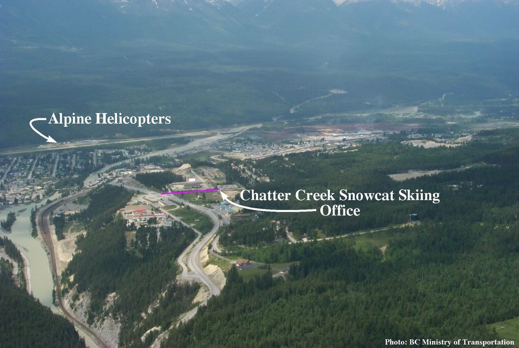
In the mid 1990's, Chatter Creek started an arduous application process for the right to operate a commercial snowcat skiing business on Crown Land and, after a lengthy evaluation and public hearings, was conferred a "recreational tenure" on 50 sq. miles, just east of Kinbasket Lake. This gives the company the exclusive right to the land for a recreation business, but confers no ownership rights and in no way bars the public from access to and recreational use of the land.

In exchange for this right, the company pays the Government an annual fee plus an head tax on its clients. It is believed that the Government could confer a subsequent tenure to a different company for a different purpose, but that would be on a non-interference basis vis-a-vis the original tenure holder. (Ie.: for summer ATV tours or summer hiking). It is also believed that the Government could withdraw tenure in favour of an operator proposing a "better" recreational use for the land. Hence, a proposal to build a large ski resort on the land might win favour over a relatively small snowcat skiing operator.
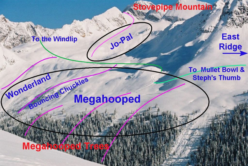
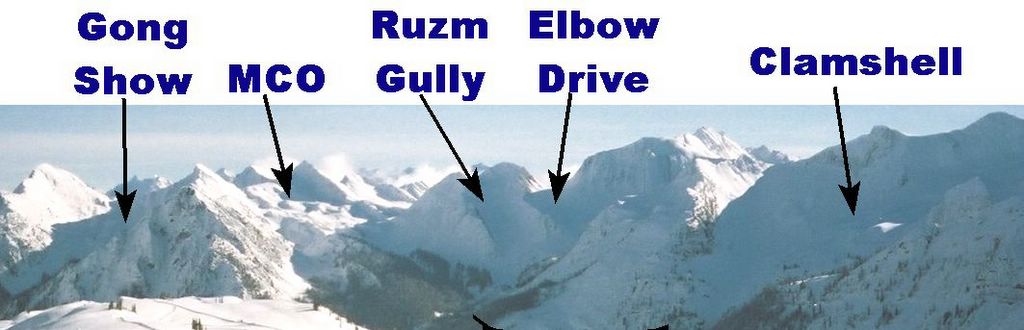
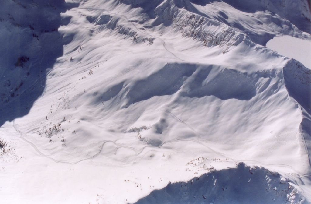
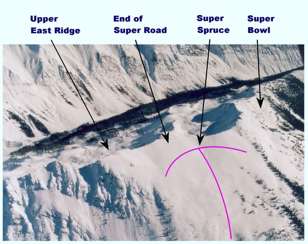
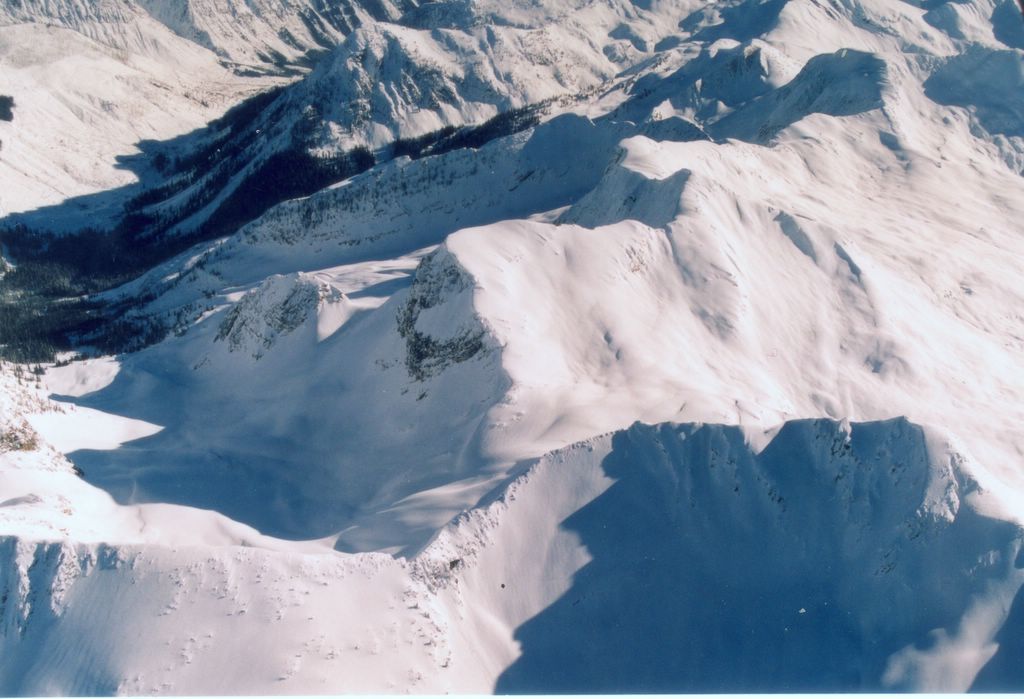
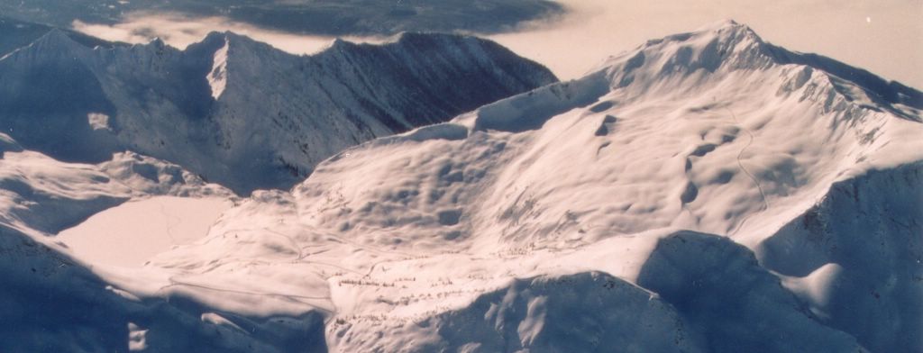
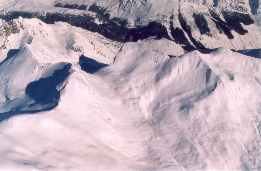
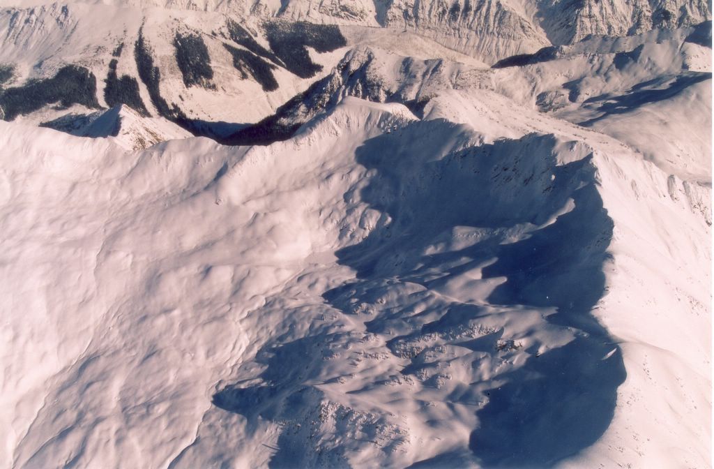
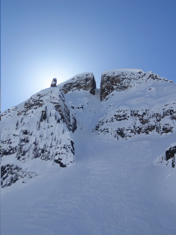
For a look at the Chatter Creek cat skiing terrain, click here.


James on his way to a Blind Date. Thanks for the photos, James. Here are more Happy Campers at Chatter Creek.


Not nearly the usual thing at Chatter Creek, but it seems to have amused James of Toronto. Thanks to Monique for this photo. Click here for a view from the top.


James of Toronto has sent us a shot of his little gem. He thinks it should be called "Blind Date", since he had no idea what he was getting into, or "Wasabe" after some Japanese companions. This is certainly NOT the usual fare at Chatter Creek. Guides choose terrain according to the capabilities of their group (and snow stability), either mellow or steep. However, this is pretty unusual! Click here for another view of this "piste". Thanks to Monique for this photo.