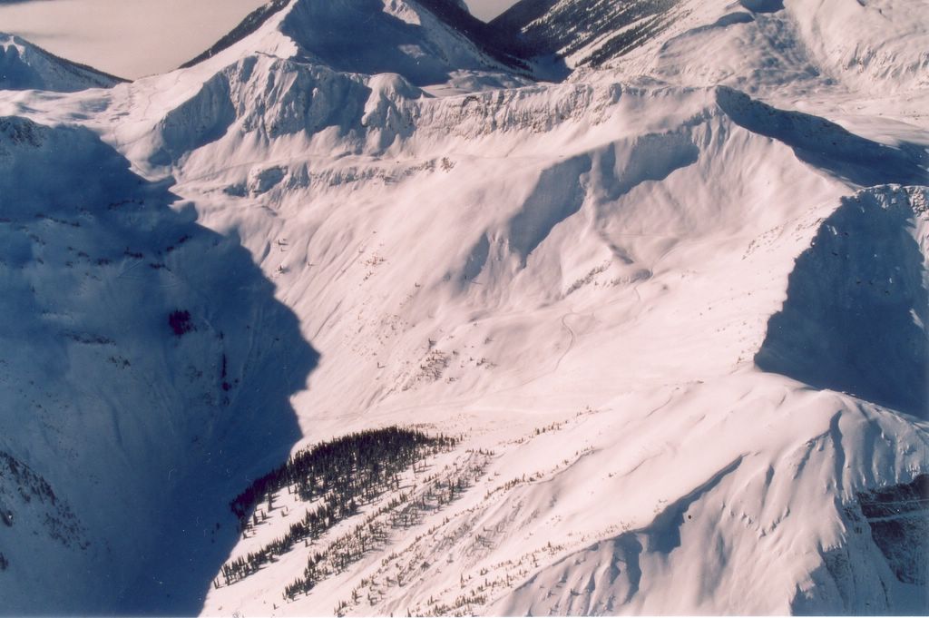
Chatter News Photo Galleries and Information ________________________________________________
| Chatter News | Road to Vertebrae Glacier | Glacier Skiing | Bombardier Snowcat | Favorites |
| Lodge Life | Vertebrae Lodge | Solitude Lodge | Happy Campers | Pink Purse | Winter Staff |
Ski Photography by: | John Dougall | Mark Gallup | Dan Hudson | Rob Plato | Site Map | Index |
| Chatter Creek Cat Skiing | Clamshell | Cut Blocks | East Ridge | Lodge Ridge | Great Links |
| Cat Skiing Terrain | Cat Skiing Articles | Flight to Chatter Creek | Travel to Golden | Email |

Thursday, March 31, 2005

Lakeview at Chatter Creek Cat Skiing

The Lakeview Ski Terrain at Chatter Creek Cat Skiing
Lakeview bowl lies south of Chatter Creek's Vertebrae Lodge. The large bowl called South Park slopes into the lake from the left. The next bowl to the north of Lakeview is MCO. Beyond MCO, East Ridge is visible, with Super Spruce to the left of the trees and the Enchanted Forest to the right. Vertebrae Ridge lies beyond East Ridge, at the top of the photo.

Other views and information about Lake View:
1. Lakeview Aerial photo # 2
2. Lakeview from the north.
3. Lakeview between Harbourview and South Park aerial photo from the south.
4. Lakeview as seen from South Park.
5. Road into Lakeview from Harbourview

Harbourview at Chatter Creek Cat Skiing


Harbourview is a large bowl located to the south of Vertebrae Lodge. The next bowl to the north is Lakeview, visible at the far left of the photo. Part of SX3 is visible behind Lakeview. SX2 lies hidden behind Harbourview, to the right of SX3. The area at the far right of the photo is not yet developed for cat skiing. The sides of Harbourview offer many powder skiing lines having a variety of steepness.
Harbourview Photos
1. The right hand image in these shots by John Dougall shows Alex Orr skiing in Harbourview.

Wednesday, March 30, 2005

Chatter Creek Cat Skiing Terrain

The Chatter Creek cat skiing terrain is accessed by five cat road networks. These start at Vertebrae Lodge and fan out to the extremidies of the tenure. Follow the links below to view photographs and descriptions of the skiing areas and runs serviced by these roads.(Notes on using this photo index)

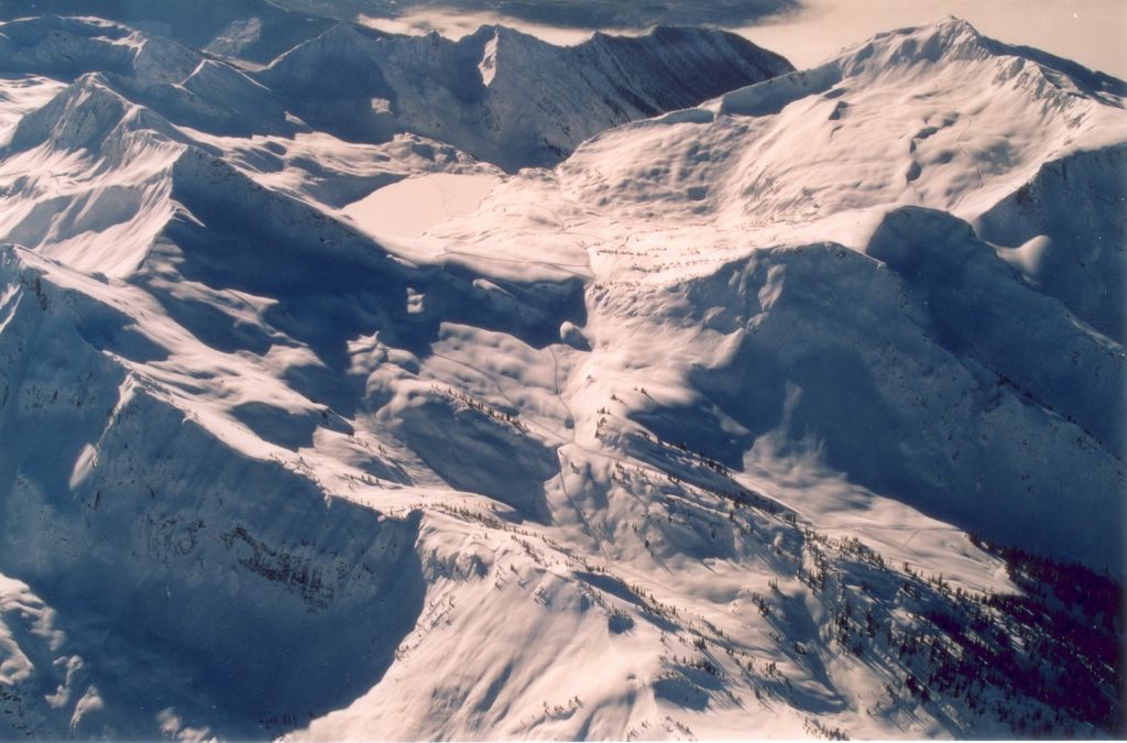
Chatter Creek is grateful to Steve Neill of Alpenglow Aviation of Golden, for much of the aerial photography presented here.

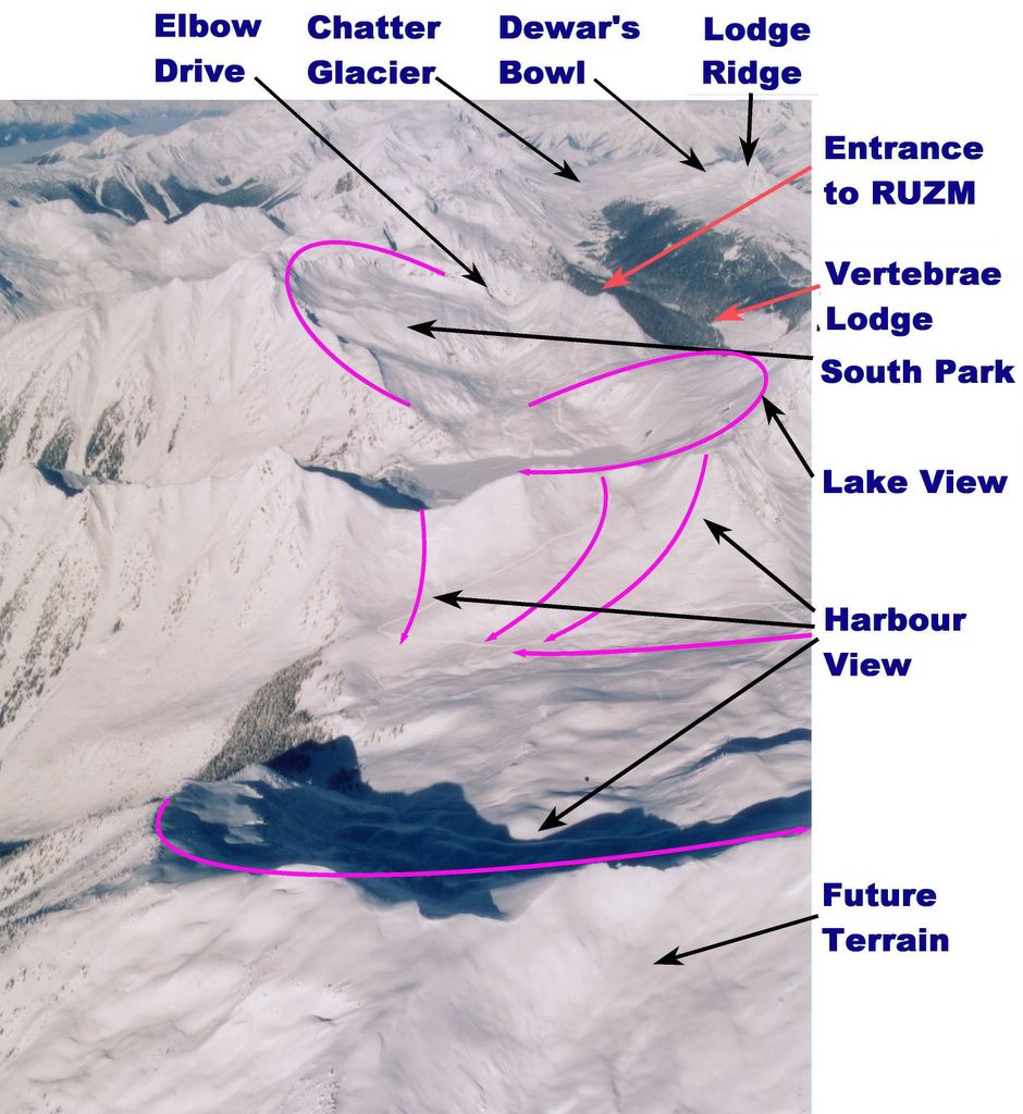
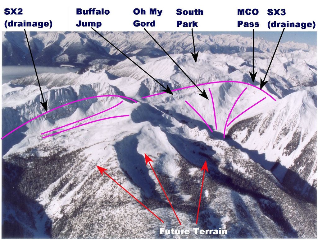
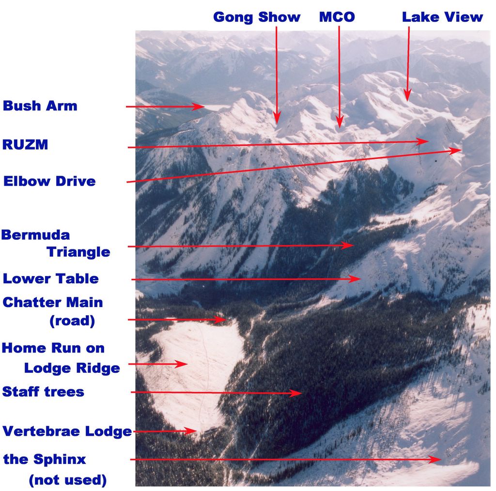
The five road networks are:
A. South Side Super Road : leaving Vertebrae Lodge, the road climbs to MCO, passes branches to Elbow Drive, RUZM Gully and the Gong Show and continues to South Park, Lakeview and Harbourview. There are also branches to SX3 and SX2.

B. West Side and Oyster Bowl Road : leaving Vertebrae Lodge, the road rises through the Staff Trees and the Table and then climbs through the Clamshell to the Pearl, which is the col at the top of the ridge to the west of the lodge. In the Clamshell, a branch crosses northward to Forbidden Fruit and the Plank. At the Pearl, the road crosses to the west of the ridge and into Oyster Bowl in the new Lakeside Addition. In Oyster Bowl the road branches north to Game Creek and south to the rest of the Lakeside Addition.

C. Lodge Ridge Road : leaving Vertebrae Lodge, the road climbs the south end of Lodge Riddge to its crest, which it follows north to a point beyond Spruce Pass on the east and close to the Chatter glacier on the west. The road services
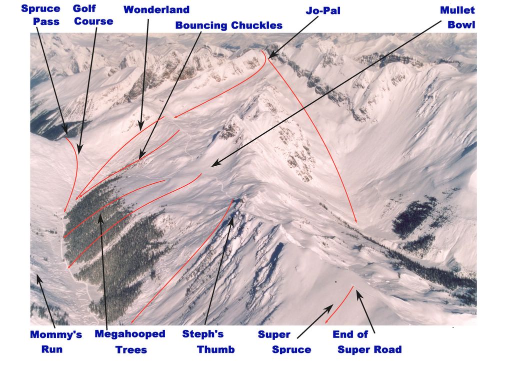
 Mommy's Run and Crystal Lite to the east and Dewar's Bowl and the Chatter Creek watershed to the west.

D. Road to Vertebrae Glacier : leaving Vertebrae Lodge, the road climbs Lodge Ridge to the Spruce Creek gully, between Lodge Ridge and the Megahooped Trees. Beyond the trees, a branch forks north to Spruce Pass. The main road turns back and climbs above the trees, where a second branch forks south to Mullet Bowl and Steph's Thumb. It then climbs Megahooped, crosses the whole slope between Jo-pal and Megahooped, and skirts a ridge to pass onto the Windlip, north of Jo-Pal. Near the top of the Windlip, the road turns through the Keyhole and onto the Plateau at the top of Vertebrae glacier. Before the Keyhole, a branch of the road forks to continue to the top of the Windlip and a pass-through to Jo-Pal. On the Plateau, a branch of the road turns southeast to cross the glacier.

E. East Ridge Road Super Road : leaving Vertebrae Lodge, the road passes south across the Home Run cut block and onto the flank of East Ridge. The road traverses the west side of East Ridge as it climbs to the crest, at it's south end, which is called the Nose. From the Nose, the road reverses direction and climbs the crest of the East Ridge north to a point on Super Spruce, high above and a little south of the Megahooped Trees.

South Side Cat Skiing Terrain at Chatter Creek

The South Side Super Road leaves Vertebrae Lodge to climb to MCO, where branches fork to Elbow Drive, RUZM Gully and the Gong Show. The road continues south to South Park, Lakeview and Harbourview. There are branches to SX3 and SX2. Here is an aerial view from above the lodge, looking south to the area serviced by this road. (bare photo)(photo with names).
South Side Photography:

A.1 Panorama view of cat skiing areas just south of Vertebrae Lodge.
A.2 MCO and South Park - view to the south (photo)(names)
       MCO (Multiple Cascading Orgasims)    MCO Pass    Gong Show
       RUZM gully       Lakeview    South Park
A.3 South Park, Lakeview and Harbourview - view to the north.
       (photo) (names)   Elbow Drive    Road to RUZM    South Park
       Lakeview     Harbourview
A.4 SX2, SX3 and Harbourview - view to the north (photo)(names)
       Harbourview     Oh My Gord     HSI Buffalo Jump
       Lakeview     South Park     Road to RUZM     SX2     SX3
       Bowling Alley     MCO Pass
A.5 SX2, SX3 and South Park- view from the east (photo)(names)
       SX2    HSI Buffalo Jump    Oh My Gord     South Park
       MCO Pass    SX3
A.6 Harbourview and SX3 - view to the north (photo)(names)
       Harbourview    Oh My Gord     RUZM Entrance     MCO Pass
       SX3    SX2

Back to Road Network Index

West Side and Oyster Bowl Cat Skiing Terrain

The West Side and Oyster Bowl Road leaves Vertebrae Lodge to climb through the Staff Trees, to cross the Table, and to rise through the Clamshell to the Pearl at the top of the ridge. A branch crosses high in the Clamshell to service Forbidden Fruit and the Plank. At the Pearl, the road crosses to the west and into Oyster Bowl in the new Lakeside Addition to the tenure. In Oyster Bowl there is a branch north to Game Creek and a southern branch to the rest of the Lakeside Addition. The Game Creek branch has a secondary branch to the top of Fruit Loops.
West Side and Oyster Bowl Photography:
B.1 Staff Trees and the Table - view to the south (photo)(names).
      Staff Trees     the Table     Bermuda Triangle
B.2 Panorama of the Kitchen Range west of Vertebrae Lodge.
      RUZM       Elbow Drive     the Pearl
B.3 The Clamshell (photo gallery)
B.4 The Clamshell - view from the east (photo)       Clamshell
       Fruit Loops     Forbidden Fruit    the Plank     Waterfall
B.5 Clamshell, Forbidden Fruit and Fruit Loops - view from the north (photo) (names)
B.6 Fruit Loops and Entrance from Oyster Bowl - view from the west (photo)
B.7 Snowcat Climbing Through the Clamshell - view looking up the West Side and Oyster Bowl Road (photo)

Back to Road Network Index

Vertebrae Glacier, Megahooped and Spruce Pass

Leaving Vertebrae Lodge, the Road to Vertebrae Glacier crosses the Home Run cut block on the southern flank of Lodge Ridge and climbs to the Spruce Creek gully, just east of Lodge Ridge. After passing beneath Megahooped Trees, the road turns east to climb above the trees . At the turn, a branch forks north past the Golf Course to Spruce Pass. Above the trees, a second branch forks south to Mullet Bowl and Steph's Thumb. The main road climbs the south side of Megahooped until it turns north on a bench that separates Jo-pal, above the bench from Megahooped below. At the northern end of the bench, the road climbs to cross a ridge and pass onto the Windlip, to the north of Jo-Pal. Near the top of the Windlip, the road forks, with an east branch continuing to the top of the Windlip and a north branch that passes through the Keyhole onto the Plateau at the top of Vertebrae glacier. By this point, the road has climbed from lodge elevation at about 5400 ft to almost 10,000 ft.
Spruce Pass, Megahooped, Windlip and Vertebrae Photography:
D.1. The Road to Vertebrae Glacier (photo gallery).
D.2. Spruce Pass (photo)
       Golf Course
D.3. Spruce Pass Addition.
D.4. Megahooped and Jo-Pal (photo)(with names).
       Megahooped Trees     Megahooped       Mullet Bowl
       Steph's Thumb       Bouncing Chuckles    Wonderland
       Jo-Pal
D.5. The Windlip (photo with names).
       Windlip     Entrance to Jo-Pal.
D.6. Glacier Skiing at Chatter Creek (photo gallery)
       Vertebrae glacier

Back to Road Network Index

Lodge Ridge Cat Skiing Terrain at Chatter Creek

The Lodge Ridge Road leaves Vertebrae Lodge, and traverses the Home Run cut block to the trees. It climbs the soutwest end of Lodge Ridge to it's crest at a point above "Crystal Lite" and "Mommy's Run" on the east and some tree runs, to the west. It continues north on the crest of Lodge Ridge to a point above the Spruce Pass Addition on the east and the Chatter glacier on the west. On it's way, the road services Dewar's Bowl and the east side of the Chatter Creek watershed.
Lodge Ridge Photography:
C.1 Skiing Lodge Ridge (photo gallery)
C.2 Lower Lodge Ridge and Lodge Site: (photo)
       Crystal Lite    Mommy's Run    Home Run    Dewer's Bowl
      Chatter Waterhsed
C.3 Lodge Ridge and East Ridge Panorama (with names).

Back to Road Network Index

East Ridge Cat Skiing Terrain and Super Road

The East Ridge Super Road leaves Vertebrae Lodge to pass south across the Home Run cut block and onto the flank of East Ridge. The road traverses the side of East Ridge as it climbs to the crest, at it's south end, which is called the Nose. From the Nose, the road follows the crest of the East Ridge north to a point on Super Spruce, high above and a little south of the Megahooped Trees.

From the Nose, north to Super Spruce, the road passes one skiing line after another, both on the east and west aspects. Runs to the east drop into the valley between East Ridge and Vertebrae Ridge. On the West, runs drop into the Chatter Creek valley. A number of the westerly runs open into large cut blocks.

Runs to the east include, the Left Nostril (at the Nose), the Trojan, Sweet Cheeks, the Phat, the Skiiny, Puma, EMOP, and Percy's Knob. Runs to the west include the Right Nostril (at the Nose), Enchanted Forest, Super Bowl and Super Spruce.
East Ridge Photograpy:
E.1 Skiing the East Ridge (photo journal)
E.2 Upper East Ridge aerial view (photo) (names)
E.3 Upper East Ridge showing Super Spruce and Super Bowl.
E.4 Lodge Ridge and East Ridge Panorama (with names).
E.5 End of the Super Road on Super Spruce.

Back to Road Network Index

South Park, Lakeview and Harbourview Areas


South Park lies above the center of the photo, Lakeview is the bowl in the center of the photo and Harbourview is the bowl near the bottom of the photo. Vertebrae Lodge lies to the north at the base of the "Home Run" cut block visible on Lodge Ridge.

Click here to see the unmarked image.

South Park, Lakeview and Harbourview


In the top third of the photo lies South Park , to the left of the distant trees on Lodge Ridge. South Park slopes from left to right , almost into Lake View, which is the next bowl closer to the camera . Lakeview is a drainage that empties to the left of the photo. Next closest bowl to the camera, just below the center of the photo, is Harbourview, partly in the shadow of its southern rim. The area at the bottom of the photo has not yet been been opened up for cat skiing at Chatter Creek.

Click here to see the names of the cat skiing areas and runs.

Using the Chatter Creek Terrain Photo Index

Chatter Creek Cat Skiing Terrain photos can be viewed conveniently in the following way. However, at least a 17 in monitor operating at a fairly fine screen resolution provides the best results.

1. Open the Chatter Creek Cat Skiing Terrain . This contains and index and links to the major cat road networks.

2. Move the road index window to the left hand side of your display and adjust the size (pull in the right hand edge) so that only the text is visible.

3. Click on the road network of interest (ed.: South Side Super Road) A page for the selected road network should appear in the same window. Use the "Back" button on the browser to select another road system.

4. On the page for the selected Road Network , click on a ski run photo link of interest. There are links to bare photos and photos with ski runs and areas marked. This should open a separate window. Position this window at the right hand side of your display, so you can see as much as possible of the photos that appear in the right hand window.

5. In the (left hand) Road Network (left hand) window, click on other ski runs of interest. These will open in the right hand window. You can examine an entire skiing zone without re-adjusting winddows.

6. To select a different road netword, use the "Back" button on the left hand window to return to the major road index.

Tuesday, March 29, 2005

SX2, SX3 and South Park Areas from the East


The SX2 and SX3 drainages as viewed from the east. South Park is visible in the background. Note: for a better view, click the image and maximixe your viewing window.

Click here to see the unmarked image. Click any Chatter News image to enlarge it. Use the browser's "Back" button to return.

SX2, SX3 and South Park Viewed from the East


The SX2 drainage is under the cliff and the SX3 drainage is to the right. South Park can be seen beyond SX3. MCO Pass is in shadow above and to the right of SX3. The treed bowls in the forground will provide future cat skiing terrain. Click the image for a better view.

Click here to see the names of the cat skiing areas show.

SX3 Cat Skiing Areas

The SX3 Drainage at Chatter Creek Cat Skiing
The SX3 drainage with the main runs and features named. The top of SX2 is hidden in the shadow at the left of the photo. SX2 is the next drainage to the south. Click here for the unmarked photo.

Photos of SX3
1. Upper SX3 and "Oh my Gord" viewed from SX2.
2. View into SX3 from above Harbourview.
3. View into SX3 from above MCO Pass.
4. Aerial view of the Bowling Alley and Oh My Gord from the east.

Branch to the "South Side Super Road" index

Click on any Chatter News photo to enlarge it. Use the browser's "Back Button to return.

The SX3 Drainage at Chatter Creek Cat Skiing


The upper SX3 drainage viewed from the east. "Oh My Gord" is in the middle of the photo and "Smashed in Head Buffalo Jump" is above center, slightly to the left. Part of South Park can be seen at the upper right. Runs in SX3 extend through the unnamed trees at the bottom of the photo. Click here to see the names of the runs and areas in and about upper SX3.
Photos of SX3
1. Upper SX3 and "Oh my Gord" viewed from SX2.
2. View into SX3 from above Harbourview.
3. View into SX3 from above MCO Pass.
4. Aerial view of the Bowling Alley and Oh My Gord from the east.

Branch to the "South Side Super Road" index

Saturday, March 26, 2005

MCO and South Park at Chatter Creek Cat Skiing


MCO (Multiple Cascading Orgasims) crosses the photo from left to right, dropping from MCO Pass. South Park rises in the background from above center to the top right hand corner of the photo. Click here for the names of runs.

Here are lists of more photos from MCO, South Park and Lakeview.
1. South Park photos and info.
2. MCO Photos (to be supplied)
3. Lakview photos and info.
                                         Return to South Side Index

MCO and South Park Cat Skiing Areas


MCO (Multiple Cascading Orgasim) and South Park with Lake View in the background. RUZM (Right up ze Middle) gully is in the shadow to the right. Click here for the unmarked image

Here are lists of more photos from MCO, South Park and Lakeview.
1. South Park photos and info.

Lakeview

The Lakeview Ski Terrain at Chatter Creek Cat Skiing
Lakeview, in the southern part of the Chatter Creek cat skiing tenure. Lakeview lies between South Park, to the north (left) and Harbourview to the south.

Harbourview and SX3 Cat Skiing Areas


View of terrain south of Vertebrae Lodge taken looking north with Lodge Ridge, East Ridge and Vertebrae Ridge in the background. Click here for the unmarked image.

Click the following links for better views of SX2, SX3 and Harbourview or for MCO and a view of South Park

South of the Lodge Cat Skiing Areas


The view to the south from above Vertebrae Lodge. The Chatter Main road can be seen exiting the far end of the Home Run clearcut. Bush Arm is 17 km away, by road. "SX2" and "SX3" are two drainages in the south that are named for the stream crossings resulting from their outflow.
Click here for a panorama view of this area from Lodge Ridge, above the Home Run cut block.

Click here to see the unmarked image. Click any Chatter News image to enlarge it. Use the browser's "Back" button to return.

South of the Lodge at Chatter Creek Cat Skiing


The view looking down on Vertebrae Lodge and to the south. The open cut block on the lower left is the Home Run on lower Lodge Ridge. The large block of trees opposite are the Staff Trees. The slide path beyond Staff Trees is the Lower Table, an exit route from the Clamshell. Beyond the Lower Table is the Bermuda Triangle (trees). The snowy knob to the right and above center contains RUZM Gully and the notch to the right of RUZM is the entrance to Elbow Drive. Both RUZM and Elbow Drive are visible, but are in shadow. In the center, beyond the trees is MCO, whiche drops down from MCO Pass. The higher bowl to the left of MCO is the Gong Show. Beyond and to the left of the Gong Show, a bit of Bush Arm can be seen. Behind RUZM, the large drainage opening to the west (right) is Lake View.

Click here to see the run and area names. Click the image to enlarge it.

Friday, March 25, 2005

Clamshell and Fruit Loops at Chatter Creek


The Clamshell, on the left, and the tower that marks its northern edge. Forbidden Fruit exits above the tower, and the Plank exits below. Both exits drop into the bottom of Fruit Loops bowl, that runs at the edge of the shadow from upper right of the center of the photo to lower left. The new Game Creek drainage is in the background, mostly in shadow. Vertigo Peak can be seen in the background, against the mist covering Kinbasket Lake. This portion of the Chatter Creek cat skiing tenure lies in the Kitchen Range of the Canadian Rocky Mountains.

Click here to see run names.

Clamshell and Fruit Loops Cat Skiing Areas


Favorite exits from the Clamshell have long been Forbidden Fruit and the Plank.These lines drop onto the bottom of Fruit Loops bowl. New terrain now permits access to the top of Fruit Loops bowl, well above Forbidden Fruit.

The top of the Game Creek drainage can be seen in the background. Snapper Head bowl is located beyond the furthest ridge. The Game Creek road traverses the far ridge, which has been marked. Click here to see the unmarked image.

Click any Chatter News image to enlarge the image. Use the browser's "Back" button to return.

Upper East Ridge at Chatter Creek Cat Skiing


Upper East Ridge lies between Vertebrae Ridge on the right, and Lodge Ridge just seen at the lower left. Click here to see run names. Click on any Chatter News image to enlarge it. Use the browser's "Back" button to return.

Upper East Ridge Cat Skiing Areas


Aerial view of upper East Ridge, Megahooped and Jo-Pal. Upper East Ridge is seen to curve and run into the flank of Stovepipe Mountain. Megahooped is the area below Jo-Pal and includes Wonderland, Bouncing Chuckles and Megahooped Trees. Click here to see the unmarked photo.

Here is a view of the end of the Super Road, high on Super Spruce.

SX2, SX3 and Harbourview at Chatter Creek


The SX2 (nearest) and SX3 drainages in the Sunnyvale area. The upper SX3 drainage includes the "Bowling Alley", "Oh My Gord" and "Head Smashed In Buffalo Jump". Click here to see the run and area names in this region.

SX2, SX3 and Harbourview Cat Skiing Areas


Aerial view over the southern protion of the Chatter Creek snowcat skiing tenure. For an unmarked view of this terrain, click here.

Click on any Chatter News image to enlarge it. Use the browser's "Back" button to return.

Friday, March 04, 2005


Thanks to our intrepid guide, Dani Loewenstein, we've figured this photo out! It's taken from above the left hand side of the Waterfall on the ski-out from Forbidden Fruit and Fruit Loops. The outrun from the Plank is well to the right. It skirts the right side of the Waterfall. Lower Table, an alternate route out of the Clamshell, is in the background. Thank's Dani.

Thursday, March 03, 2005

South Park from MCO


This photo is taken from the top of MCO looking across to Ruguy ridge and the drop off of Rezum on the right. South Park is in the background. Thanks again, Dani!

Powder Skiing at Chatter Creek
Looking down the center of South Park to the main pickup point. MCO is over the ridge in the background. Here's another shot from South Park.


South Park is a large bowl in the southern reaches of the Chatter Creek tenure. Here's another shot from the same area.